GNSS TEC and Monitoring of Ionosphere

Ionosphere is generally modeled as thin layer in GNSS processing. STEC (slant total electron content) for individual satellite is mapped into the earth's surface, called as VTEC (vertical TECi, or TEC).
Animation (every 5 minutes) of TEC from 9:00 to 17:00 UTC of August 24, 2005.
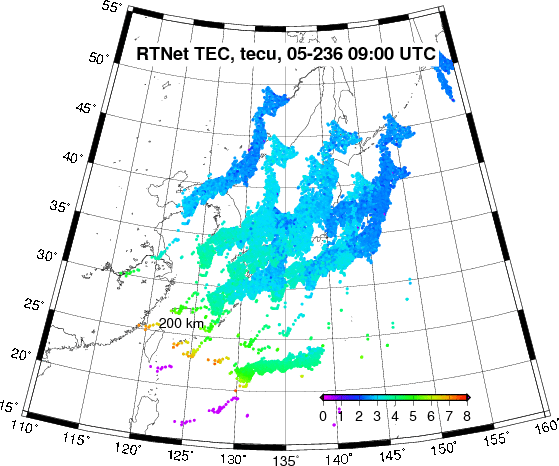
Snapshot of TEC at 11:30 UTC of August 24, 2005.

The map above shows TEC distribution (slant TEC in the thin ionosphere layer is mapped into the earth). GIM (Global Ionospheric Model) is used to estimate receiver DCBs in several days processing prior to target processing day, and the DCBs are used then to estimate absolute TEC for the target day. RTNet makes it possible to monitor space weather such as TID (Traveling Ionospheric Disturbance) which affects radio communication system.
With real-time data streaming, true real-time monitoring (latency of a few seconds) of space weather is also possible.
Ionospheric Model for L1 Processing
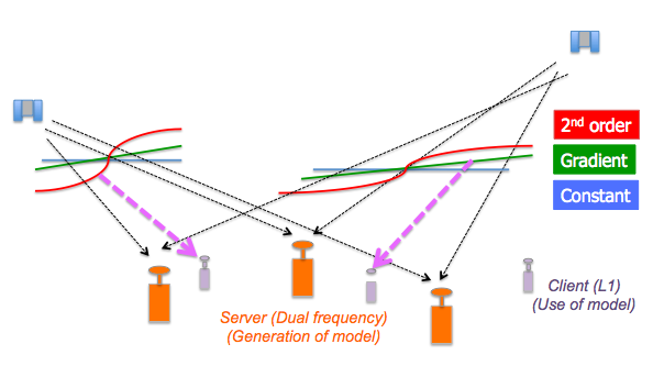
RTNet can generate ionospheric model based on dual frequency network (server network) for inexpensive L1 receiver inside of the server network. Ionosphere is modeled as constant, 1st and 2nd order gradient models.