GPS (GNSS) Meteorology : Operational Processing and Forecast
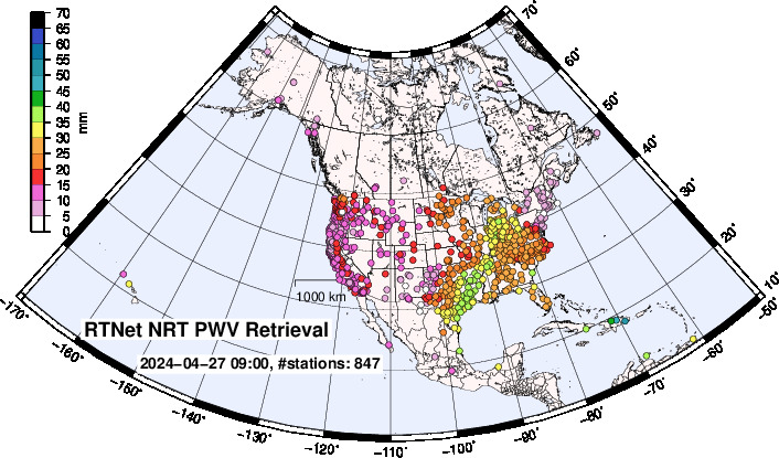
Near Realtime (NRT) PWV with RTNet GPS-MET System
| RTNet NRT PWV in US | RTNet NRT PWV in CONUS |
 |
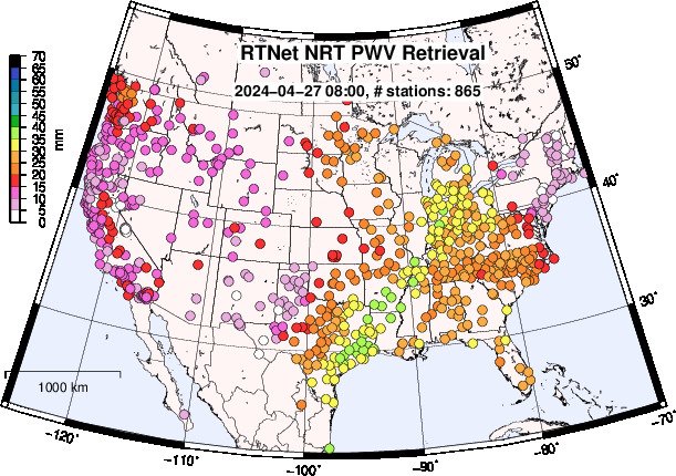 |
(Left): The continuous nrae real-time (NRT) PWV (with latency of 18~60 minutes, depending on availability of RINEX data) product in US and global networks. (Right): Same with left map but magnified plots for CONUS. Currently we are processing 1,362 US and global stations (data arrived within cut-off time is processed in each scheduled processing time), and generate NRT PWV products for weather forecast.
The continuous NRT RTNet PWV processing system service can include GNSS stations (RINEX or real-time data) at any locations, process the data with high quality multi GNSS satellite clock products, and provide PWV and slant delay prodcuts to users.
"True" Realtime ZTD Processing with RTNet
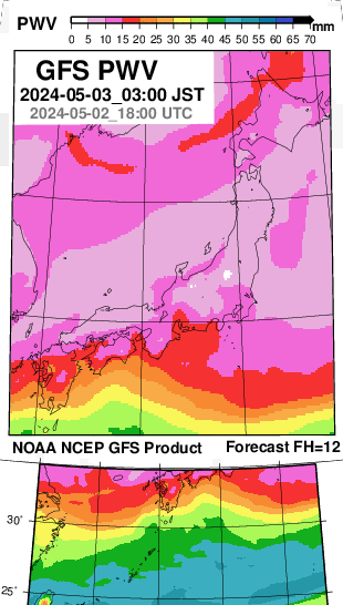
| Analysis Rainfall | RTNet Realtime PWV | NOAA NCEP GFS Forecast (12h) |
 |
|
 |
| Link to comparison with GNSS PWV |
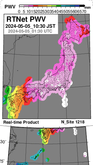
(Left) The real-time PWV (with latency of 1~2 minutes) product in Japan is used for multiple organizations for weather forecast service.
(Middle): The middle figure shows analysis rainfall from https://www.imocwx.com/rdam/rd0_jp.htm
(Right): As optional service, GNSS PWV products are compared wirh analysis/forecast field of PWV in numerical weather prediction system (NOAA NCEP GFS). Comparison with radiosodnde PWV (integrated wet refractivity for zenith direction) is also possible if data is available inside of GNSS processing network.
CFW: GPS-Enhanced Operational Forecast System Version. 4
CFW (Click For Weather) OP4: Now up to 5~7 days forecast is avilable.
YRAIN.COM : Forecast is available for some specific cities and airports.
GNSS Meteorology with RTNet

The maps show flow of conversion from GNSS ZTD (zenith tropospheric delay) to PWV (precipitable water vapor). ZTD has contribution from pressure and thus the map (1) has strong constrain with topography, while PWV map (8) has much less effect of altitude and has information on water vapor distribution.
Real-time PWV Estimation in Japan 

Data is provided throuth Hitachi Zosen Corporation, Japan.
RTnet Met System

RTnet provides real-time, near real-time, and post processed zenith tropospheric delay (ZTD) estimates.
The unique feature of RTnet estimate is the solutions is available with a few seconds after arrival of real-time data. Precipitable water vapor (PWV) converted from ZTD (based on surface pressure and temperature observation) can be used for meteorological application with require data with short latency.
GPS-enhanced Operational Forecast System
We support to set-up operational numerical weather prediction (NWP) and data assimilation (DA) system (based on WRF model) for your GNSS network as an optional package. High resolution forecast with frequest DA system is available to maximize potential of GNSS PWV data.
Current results of impact test with GPS PWV in OFS is available in:
Data Assimilation of GPS PWV : US High Resolution GPS Enhanced Point Forecast
NRT Processing and Post-Processing

Comparison of IGS ZTD product and RTNet ZTD for 10 days. RTNet processing was performed with seamless mode based on multiple RINEX files. RTNet ZTD solution doesn't have jump in the day boundary which is observed in IGS ZTD solution.
GNSS Processing in Moving Platform
RTnet can be used to estimate ZTD in moving platforms such as vessels, ocean buoy, and viechles. Coordinates of the moving platforms are estimated with ZTD at observation sampling epoch.
Please see references for details on accuracy and application:
Oishi et al., 2012 (ION GNSS+ 2012), Kanzaki et al., 2011 (ION GNSS+ 2011), and Fujita et al., 2008 (GRL)
GNSS Climatology
RTnet can estimate consistent ZTD products with re-processed GNSS satellite products, required for climatological researches.
Please see references for details on accuracy and application:
Fujita et al., 2012 (ION GNSS+ 2012)
Click For Weather System Package
Operational Numerical Weather Forecast System

Real-time or NRT GPS PWV can be assimilated into numerical weather forecast (NWP) system. To maximize benefit of continuous GPS PWV observation, we recommend to assimilate GPSPWV multiple times in longer data assimilation time window.
The figure above show data assimilation (DA) system in Continental US (CONUS) domain in operational forecast system (OFS) version 3 in Click For Weather package. GPS PWV is assimilated every hour for 4 times in 3 hour DA time-window.